Hawaii In A Hurry
Elapsed time to paradise:
5 hours on a plane from San Francisco to Lihue.
25 minutes renting a car.
20 minutes in the car to Poipu.
5 minutes at Snorkel Bob’s renting gear in Koloa.
15 seconds under water at Beach House and my companion comes up sputtering through her snorkel mask, “They are all right here!”
 They are the bold black and gold Moorish Idol, the sinuous snowflake moray eel gracefully curving through cracks in the coral, the comical puffer, the silvery needlefish floating an inch under the surface, electric blue parrotfish, schools of long-nosed golden butterfly fish.
A few feet from the sand at Beach House, a few steps down the block from our condo, some of the best snorkeling in the world waits to be discovered. Offshore, a few hundred yards, two longboard surfers take turns catching the last outer break while the sun sets and the sea flattens. This is a guide to Kauai for the hectic, the harried, the hurried. And while nothing comes close to a week or more on the island, for those with a long weekend to spare, here’s Hawaii in a heartbeat.
Where to stay:
Prince Kuhio Condos in Poipu Beach offer a reasonably priced and central location, with beach views from the third floor condos. From here you can walk to great snorkeling and surfing spots, drive to boogie boarding beaches at Shipwreck (across from the Hyatt) and Brennecke Beach (with its baby beach perfect for families with young kids) and strike out further a field for day hiking the Na Pali cliffs or coasting down Waimea canyon on a bike. It’s a short drive into Koloa Town, a sleepy cross road conglomeration of grocery store, t-shirt, trinket, and time-share shops, plus Lappert’s coffee, a great place to start the day with a latte and sticky bun the size of your head.
What to do:
Snorkeling:
If you stay at Prince Kuhio, keep it simple. Cross the street, and get in the water at the Beach House. Done. It’s that easy, and the snorkeling is that good. Beach House is also known as Lawa'i Beach.
If you want something more adventurous, throw your gear in the car and head for the end of the road. No kidding. Take highway 56 and when the road stops, park and get out. That’s Ke’e beach at Haena State Park at the foot of the Na Pali cliffs. You’ll pass Hanalei Bay (home of the movie South Pacific and the Peter Paul and Mary song, Puff the Magic Dragon), Tunnels (a favorite surf and snorkeling spot), and some excellent places to kayak.
Parking is tricky at Ke’e so be prepared to drive down the dirt road until you can find a space. The snorkeling is worth the drive, and if anything, even better that at the Beach House. On calm days you can venture out beyond the reef and swim with the sea turtles. But don’t ever try this when the surf is breaking over the reef.
Hiking
Bring sturdy shoes and a couple bottles of water and after snorkeling Ke’e, hoof it over the Na Pali cliffs. These are knife edge volcanic cliffs and the trail is billy goat steep. Two miles in you’ll find a secluded beach and a stream pouring out of the mountains. It’s a perfect spot to picnic, find a swimming hole and soak your bones until you are ready to hike back.
Kayaking
Hanalei Bay not only boasts some of the most spectacular scenery on the island, it is home to the Hanalei River, a gently flowing, family friendly river. Along the banks sharp-eyed birders will spot night herons, gallinules, the Hawaiin state bird, the nene. Kayak Kauai, an outfitter out of Hanalei, leads tours into the serene Waioli Valley and out to the Puupoa reef.
Bicycling
This is your chance to ride downhill for hours. 13 miles of smooth blacktop from the rim of Waimea Canyon descend 3600 feet to the Pacific. Two trips are lead each day – one at the crack of dawn and one at the end of the day by Outfitters Kauai. Check in for the dawn patrol tour at 6 am and you’ll be done by 10:30, which means you’ll have plenty of time to spend the day at the beach.
Boogie Boarding / Surfing
Brennecke Beach and Shipwreck, on the south shore. Drive past the Hyatt, find a place to park, and you’re at the golden sands beach known as Shipwreck. The shipwreck is long gone but some of the best surfing on the south shore is here, especially in the afternoons. Beginners and families with kids should take a lesson with surf champ Margo Oberg. She guarantees you’ll catch a wave in one lesson.
Brennecke Beach boasts a gentle shore break that’s perfect for boogie boarding or body surfing. It’s a small beach, and sheltered enough to be safe for beginners. Rent boogie boards at Snorkel Bobs in Koloa Town or Nukumoi Surf Shop across the street from Brenneke’s.
How to get there:
Non-stop flights to Lihue Airport on Alaska Airlines from Seattle, American Airlines from LA, United from San Francisco and LA, and US Airways from Phoenix put the aloha spirit within reach for those with a long weekend.
posted by Sam McMillan @ 4:54 PM
0 comments
![]()
![]()


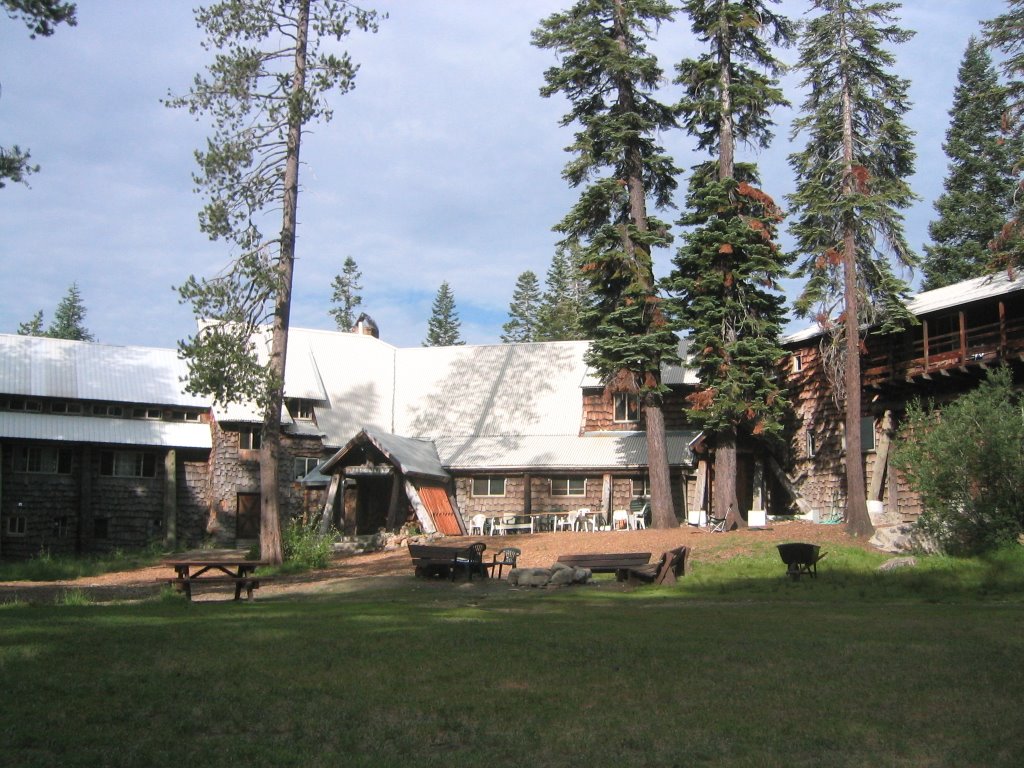
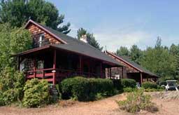
 In the winter you wont find lift lines here. In fact you wont find any lifts. But you can strap on your cross country skis and go skiing right out the back door, up into the high country overlooking the Emigrant Pass. The lodge rents cross country skis and snowshoes. A shuttle bus stops out front and will take downhill skiers to a number of ski runs in the area including Boreal and Sugar Bowl.